Basic Concept Of Surveying

Introduction

Earth is an oblate Spheroid.

Diameter= 12740 km ( Average) Average Radius = 6370 km

At Equator = 12756.75 km           At Poles= 12713.80 km

 Difference = 42.95 km  (0.34 % of Length)

Theory Of Surveying

Geodetic Surveying–  If earth curvature is considered for Survey work called Geodetic Surveying.

Plane Survey– If earth curvature is not considered suitable for small distance called as Plane Survey.
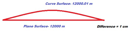
Fig. Earth Surface

Principal of Surveying

Location of Point is measured w.r.t two reference point.

In this category various surveying comes.

  1. Chain Survey
  2. Compass Survey
  3. Traverse Survey
  4. Offset Method etc. 

Working Whole to Part.

Major control points are decided and measured accurately with high degree of precise. Minor details can be collected later to avoid the error to be accumulated.

Linear Measurements

You have to study very deeply the following point refer some standard books. These points are as below.

  • Scale – Types of scale
  1.   Plane Scale
  2. Diagonal Scale
  3. Vernier Scale
  4. Shrunk Scale     

Note- Take Complete Knowledge Tape Correction 


Chain Survey

It is also Known as Limitting Length of Offset.

Imp. Point of Chain Survey—–

  • Main Stations- Major Control points to devide the area.
  • Main Lines- Lines Joining Main Stations.
  • Base Line- The longest line in the area that divide the total area almost in two parts.
  • Check Line- Check Line are measured to check the accuracy of Survey work done.
  • Tie Line- Any Line drawn to collect more information about different Object in area.( for Collecting Details)

Compass Survey

  1. Meridian – A fixed line w.r.t which bearing of line can be measured.
  2. Bearing – Angle measured w.r.t a fixed meridian.
  3. True Meridian – The line joining True North and True South on Earth Surface is called true meridian.
  4. True Bearing- The Bearing measured w.r.t True meridian is called true bearing.
  5. Magnetic Meridian 
  6. Magnetic Bearing.

System Of Bearing Measurements-

  1. WCB Method ( Whole Circle Bearing Method)
  2.  QSB System ( Quadrantal System of bearing) also called Reduced Bearing. 

Reciprocal Leveling

Reciprocal Leveling used to find out any error in the leveling instrument and to eliminate the affect of such error and other errors like due to earth curvature and refraction.

Contours

Contours are the locus of equal elevation point on ground surface.

Plane Table Surveying

There are four methods-

  1. Radiation
  2. Intersection
  3. Traversing 
  4. Resection

Again in this Three Point Problems are there-

  • Tracing paper method
  • Bessel’s graphical method
  • Lehman’s Method

Tachometer Surveying

Using a Tachometer Staff reading can be read to calculate the R.L of point, as well as distance of the staff location the instrument.

Surveying is not only a engineering subject but also a Life Lesson how science works.

Thank you. Have a Nice Day. 

3 thoughts on “Basic Concept Of Surveying”

  1. I’m extremely pleased to discover this website. I wanted to thank you for ones time just for this fantastic read!! I absolutely enjoyed every part of it and i also have you bookmarked to see new stuff in your site.

Leave a Comment

Your email address will not be published. Required fields are marked *

You cannot copy content of this page

error: Content is protected !!
Scroll to Top

CONGRATULATIONS

The Form Has Been Successfully Submitted.